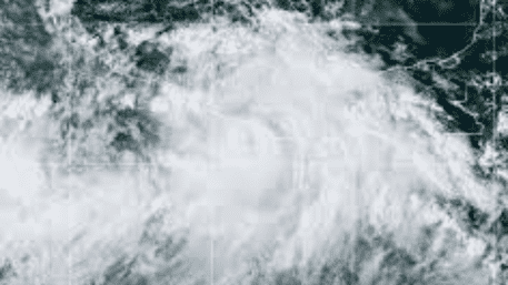
Hurricane John, which formed in the Eastern Pacific Ocean, has unexpectedly intensified into a Category I hurricane as of Monday afternoon, according to the U.S. National Hurricane Center. Initially predicted to remain a tropical storm, John has rapidly strengthened, currently boasting maximum sustained winds of 100 mph (155 km/h).
Current Location and Trajectory
The storm was last located south of Punta Maldonado, off Mexico’s Pacific coast, and is advancing toward the state of Oaxaca, with a forecasted landfall expected on Tuesday. The hurricane is moving at a speed of 6 mph, making its precise landing spot uncertain as its path continues to shift.
High Alert in Oaxaca
Oaxaca, known for its resort towns and tourist attractions, is now on high alert in response to the impending hurricane. Residents and visitors have been warned to prepare for hazardous winds and “life-threatening” flash floods. Heavy rainfall in the area has already led to significant flooding, rendering many streets nearly impassable.
Tourists and Local Preparations
Despite the inclement weather and hurricane warnings, videos have surfaced showing tourists navigating the flooded streets, highlighting the area’s popularity as a vacation destination. Local fishermen have also begun pulling their boats from the ocean to prevent damage from the approaching storm.
Potential for Further Intensification
Initially categorized as a Category 2 hurricane, John was projected to continue gaining strength, potentially escalating to a major Category 4 hurricane before making landfall. The situation remains dynamic, and officials continue to monitor its progress closely.


