
A strong 6.9-magnitude earthquake struck off the coast of Papua New Guinea’s New Britain Island early Saturday morning, shaking the region and prompting tsunami warnings, according to the United States Geological Survey (USGS).
Epicentre & Timing
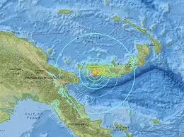
The quake hit at 6:04 am local time (2004 GMT) and was located approximately 194 kilometres southeast of Kimbe, the nearest major town. The epicentre was shallow, at a depth of just 10 kilometres (6 miles)—a factor that increases the intensity of ground shaking.


Tsunami Risk
The US Pacific Tsunami Warning Center issued an advisory warning of tsunami waves potentially reaching 1 to 3 metres in affected areas. Smaller waves under 0.3 metres were also expected in regions like the Solomon Islands.
Aftershock Reported
Roughly 30 minutes later, a second quake measuring 5.3 was recorded in nearly the same location, heightening concerns about ongoing seismic activity.
Region Known for Quakes
Papua New Guinea lies on the Ring of Fire, a highly active seismic zone stretching through Southeast Asia and across the Pacific. While earthquakes are frequent, their effects can be devastating, particularly when triggering landslides or tsunamis.
As of now, there are no immediate reports of major damage or casualties, but authorities are monitoring the situation closely.

