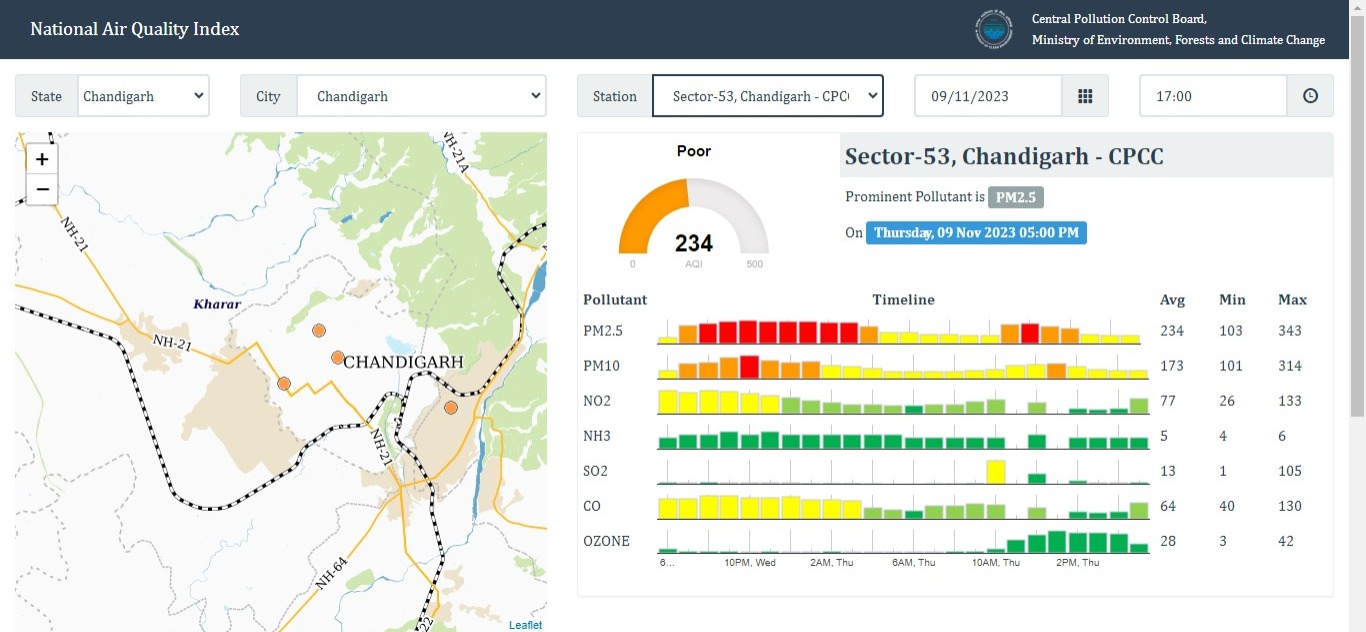
Following two days of moderate air quality levels (101-200), the Air Quality Index (AQI) took a downturn on Thursday, shifting back to the poor category (201-300). The initial impact was observed in the southern parts of the city, later spreading to the rest of the region. On Thursday at 5 pm, Chandigarh AQI is 234.
The Continuous Ambient Air Quality Monitoring Station (CAAQMS) in Sector 25 experienced the highest AQI, exceeding 200 since morning and reaching 225. Meanwhile, the CAAQMS in Sector 22 maintained a level below 200 until the evening but rose to 203.
Notably, the Sector 25 CAAQMS, located in the city’s periphery, has yet to register an AQI over 200 this season. Panchkula maintained better air quality compared to Chandigarh, recording an AQI of 133 at the Haryana Pollution State Control Board observatory in Sector 6, Panchkula.
An AQI between 201 and 300 can cause breathing discomfort with prolonged exposure, affecting even those without respiratory or heart conditions. AQI levels between 101 and 200 also pose a risk to individuals with pre-existing lung and heart diseases.
Explaining the rise in AQI, Manmohan Singh, the director of India Meteorological Department (IMD) Chandigarh, attributed it to the influence of a fresh Western Disturbance (WD). He stated, “Due to the WD, the prevailing winds in the region have shifted, directing pollutants from the Gangetic plains towards this area. This effect is expected to persist in the coming days.”
The IMD director mentioned the possibility of light rain in the city on Thursday, courtesy of the WD. While the WD is not particularly strong, even a drizzle could contribute to improved air quality. However, Singh cautioned that shallow fog might begin forming after the WD passes around November 10, with temperatures likely to decrease. On Wednesday, the maximum temperature rose from 28.6°C on Tuesday to 30°C, surpassing the normal range by two degrees. The minimum temperature also increased from 12.7°C to 13.6°C, consistent with seasonal norms.The forecast for the next three days indicates maximum temperatures ranging between 25°C and 29°C, and minimum temperatures hovering between 15°C and 16°C.


